21 Incredible Day Trips from Phoenix That Belong on Your Arizona Bucket List

People love to say Arizona is all desert, all heat, all the same. But after months of vanlifing through the state, using Phoenix as a home base more than once, I realized that couldn’t be further from the truth. Within just a few hours, the saguaros give way to pine forests, red rocks, lakes, ghost towns, and places that could not be more different from the big city.
These are the best day trips from Phoenix, each one less than three hours away and organized by distance, so it’s easy to plan. If you’re itching to get out of the sprawl for a day and see what Arizona’s really hiding, start here.
Easy Day Trips from Phoenix: Less than 1 Hour
1. Papago Park, Phoenix

Distance: 9 miles / 13 minutes
Type: Nature & Outdoors
Best Time to Go to Papago Park: Year-round
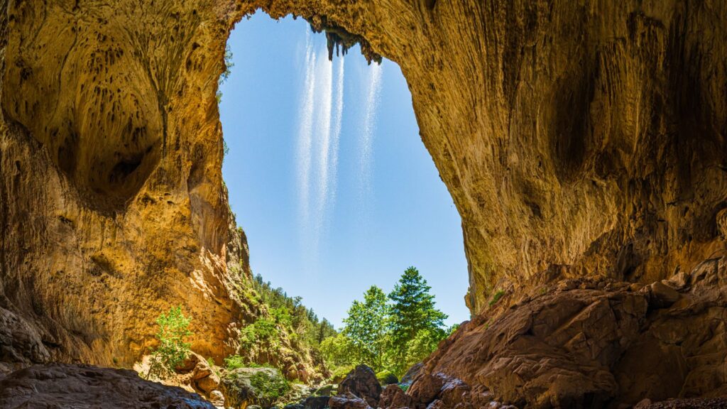
There’s a cave in the middle of Phoenix where locals go to catch the sunset and pretend the city doesn’t exist for a minute. It’s called Hole-in-the-Rock, and it looks exactly like what it sounds like.
Papago Park is one of the rare spots where you can see palm trees, buttes, fishing ponds, and prehistoric rock formations without having to drive more than ten minutes from downtown. The surrounding trails are more like walks than hikes, and the Phoenix Zoo is right next door.
2. Desert Botanical Garden, Phoenix

Distance: 9.6 miles / 14 minutes
Type: Educational
Best Time to Go: Fall for cooler walking weather
There’s a plant here that smells like rotting meat and only blooms once a decade. That’s just one of the reasons people keep coming back to the Desert Botanical Garden. With over 50,000 desert plants packed into trails, every season is different here.
The garden mixes its plant collections with art exhibits that take over the landscape. They light it all up for evening events like Las Noches de las Luminarias.
3. White Tank Mountain Regional Park

Distance: 32.7 miles/40 minutes
Type: Nature & Outdoors
Best Time to Go: Spring for wildflower blooms
White Tank is the largest regional park in Maricopa County, extending across more than 30,000 acres of desert terrain. If you want real desert hiking without leaving far from the city, this park is the go-to.
You can find short family walks to full-day loops with challenging elevation. The Waterfall Trail is a favorite, especially after rainfall when the seasonal cascade actually appears. You’ll walk past petroglyphs carved by the Hohokam. For stargazing, night hikes are popular when the park stays open later, and the skies here stay impressively dark.
4. McDowell Mountains, Scottsdale

Distance: 40.3 miles / 55 minutes
Type: Nature & Outdoors
Best Time to Go to McDowell Mountains: Fall for cooler hikes
The McDowell Mountains cover tens of thousands of acres, stitched with trails for hiking, biking, and people escaping office jobs for a few hours. Gateway Trailhead is one of the easiest places to jump in. From there, you can stick to mellow loops or aim higher for peaks like Tom’s Thumb.
On weekends, the parking lot fills up early, but the trail system is big enough that it rarely feels crowded once you’re out there.
5. Lake Pleasant Regional Park

Distance: 40.4 miles/45 minutes
Type: Nature & Outdoors
Best Time to Go: Summer for water activities
Lake Pleasant is one of the largest reservoirs in Arizona, covering more than 10,000 acres. It’s the spot where you want water without driving hours north.
Rent jet skis, take a pontoon boat out for the day, or go wakeboarding. There’s even scuba diving in the deeper sections. For hiking, Pipeline Canyon Trail offers quick views of the lake with a footbridge crossing the water during high season. If you’re up early, this is also a popular launch point for hot air balloons.
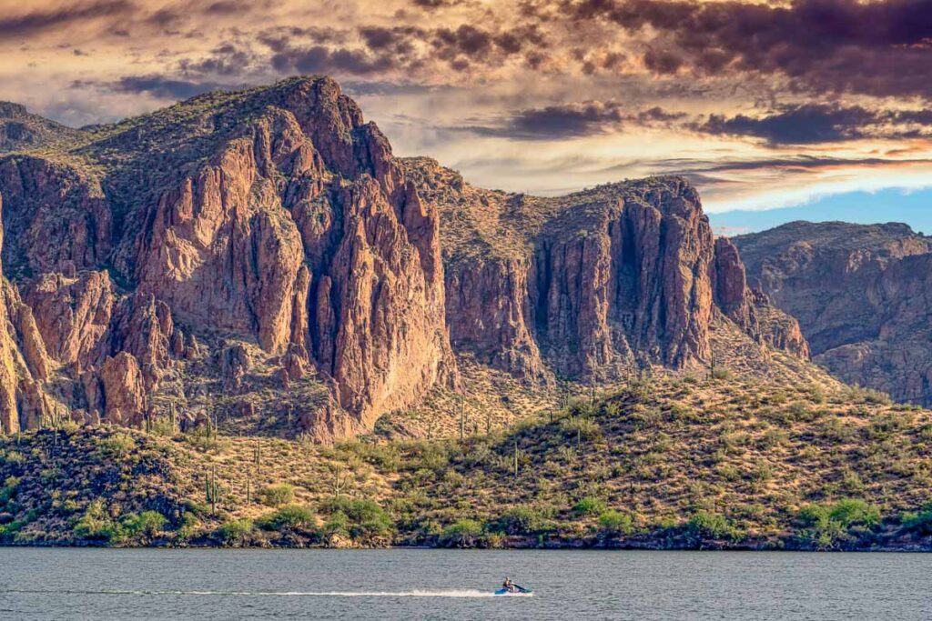
6. Saguaro Lake & Salt River
Distance: 40.8 miles/50 minutes
Type: Nature & Outdoors
Best Time to Go: Summer for tubing and kayaking
Saguaro Lake was formed by the Stewart Mountain Dam and is surrounded by the Tonto National Forest. Despite being under an hour from Phoenix, it feels like a mini vacation.
Tubing the Lower Salt River is a classic summer ritual. For a quieter route, rent a kayak or paddleboard and explore the lake’s narrow inlets and sandstone cliffs. Wild horses sometimes graze near the riverbanks. The Desert Belle offers narrated boat rides through the canyon-lined waters to cool down from the Arizona heat.
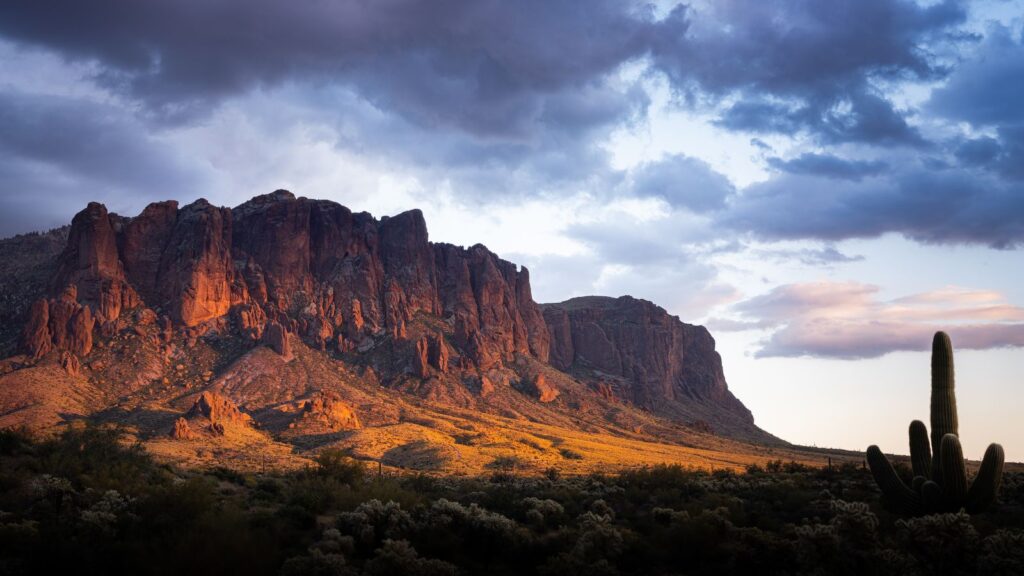
7. Superstition Mountains / Lost Dutchman State Park
Distance: 41.6 miles/55 minutes
Type: Nature & Outdoors
Best Time to Go: Fall for cooler hiking weather
The Superstition Mountains are steeped in myth and mystery, especially the legend of the Lost Dutchman’s Gold Mine. Lost Dutchman State Park sits at the base of the jagged range and gives access to some of the best trails in Central Arizona.
Siphon Draw leads into the Flatiron, a tough climb with panoramic views from the top. There are easier loops through desert flats if you’re not up for the steep stuff. The surrounding Tonto National Forest opens up even more hiking and backpacking routes.
Best Day Trips from Phoenix: Less than 2 Hours
8. Jerome

Distance: 85.7 miles/1 hour 55 minutes
Type: Historical & Cultural
Best Time to Go to Jerome: Fall for cooler air and fewer crowds
Jerome was once one of the richest mining towns in the West, perched on Cleopatra Hill with views that span across the Verde Valley. It nearly became a ghost town after the copper boom ended, but artists, eccentrics, and entrepreneurs brought it back.
Now, abandoned buildings lean into the hillside while shops, studios, and galleries wind along narrow streets above steep drop-offs. The Jerome State Historic Park inside the Douglas Mansion gives a good look at the town’s mining history. The Gold King Mine and Ghost Town are more scrappy but full of weird Americana and ghost tours.
9. Coconino National Forest, Northern Arizona

Distance: 89.8 miles / 1 hour 35 minutes
Type: Nature & Outdoors
Best Time to Go to Coconino National Forest: Fall for changing leaves in Oak Creek
This forest covers almost two million acres and manages to pack in everything from red rock cliffs to alpine lakes. When the rest of Arizona feels like a furnace, locals head north to Coconino for some actual summer relief. The elevation climbs fast, and the temperature drops just enough to make you forget it’s still triple digits back home.
West Fork Trail is one of the best ways to get into the shade, with stream crossings and canyon walls towering overhead. Near the Mogollon Rim, you’ll find pine forests that look nothing like the desert and go on for miles. It’s also one of the only places in the state where you’ll see fall colors that kind of compete with the foliage places back east.
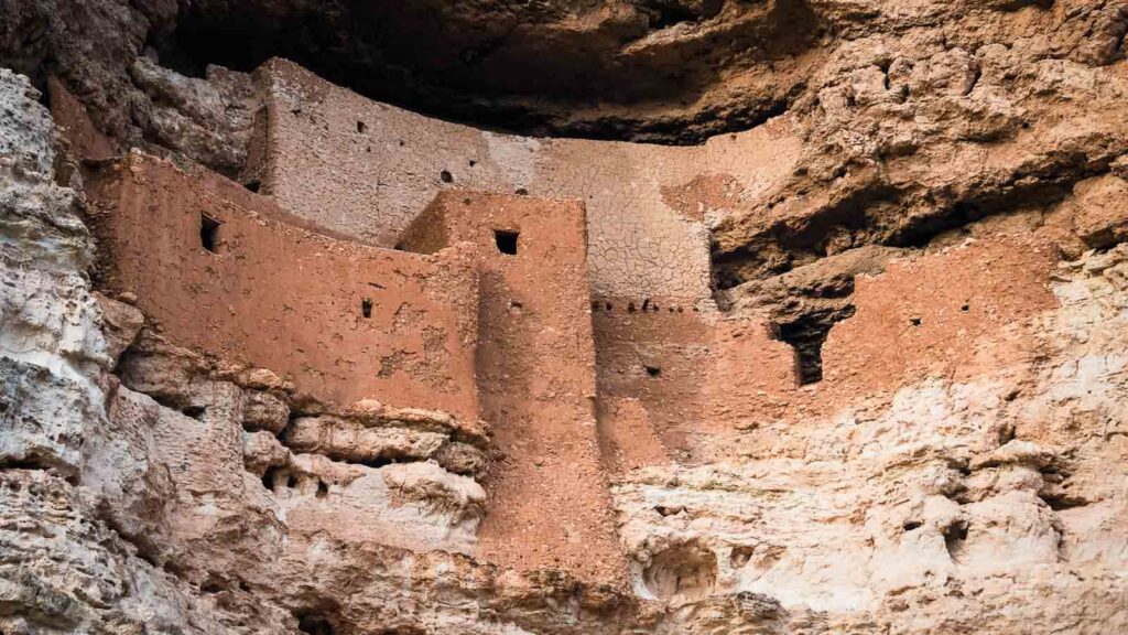
10. Montezuma Castle
Distance: 93.2 miles/1 hour 30 minutes
Type: Historical & Cultural
Best Time to Go: Fall for cooler temperatures
Montezuma Castle isn’t a castle and has nothing to do with Montezuma. But this five-story cliff dwelling carved into limestone draws thousands each year. It’s one of the best-preserved examples of Sinagua architecture in the Southwest.
The main structure is built about 90 feet up into a cliff face and once housed around 30 to 50 people. Visitors can’t go inside, but the short loop trail takes you right below it, and the scale is impressive. There’s also a small museum and another nearby site called Montezuma Well, where a natural spring-fed pool supports rare species that live nowhere else. This is a quick and educational stop, often combined with other Verde Valley towns nearby.
11. Watson Lake, Prescott

Distance: 99.3 miles/2 hours
Type: Urban
Best Time to Go to Prescott: Summer for milder mountain weather
Prescott was Arizona’s original territorial capital. At over 5,000 feet elevation, it’s a complete change of scenery and climate from Phoenix. The town center is anchored by Whiskey Row, once home to more than 40 saloons. It still has live music venues, shops, and art spaces set in historic buildings.
Beyond downtown, Watson Lake steals the show with its cracked granite boulders that rise straight out of the water. There are hiking trails around the shoreline and plenty of spots to paddle if you bring or rent a kayak. The combination of walkable town and outdoor access makes Prescott one of the easiest full-day getaways.
12. Cottonwood

Distance: 103 miles/1 hour 40 minutes
Type: Urban
Best Time to Go to Cottonwood: Spring for patios and tasting rooms
Cottonwood has become a Verde Valley favorite, especially for people skipping the Sedona crowds. Once a sleepy agricultural stop, it’s now one of Arizona’s low-key wine hubs.
Old Town Cottonwood is the center of it all. It’s walkable, packed with tasting rooms, galleries, and locally owned shops that fill out historic storefronts. The town is also close to outdoor spots like Dead Horse Ranch State Park and the Tuzigoot National Monument, an ancient pueblo ruin.
13. Biosphere 2

Distance: 112 miles/2 hours
Type: Educational
Best Time to Go to Biosphere 2: Year-round
Biosphere 2 was once the site of a sealed ecosystem experiment meant to simulate life on other planets. Today, it’s a University of Arizona research facility open to the public.
The massive glass-and-steel structure covers multiple environments, including rainforest, ocean, savanna, and desert biomes, all under one roof. Guided tours take you through the different zones and the infrastructure that kept the original sealed habitat running. You’ll also see ongoing experiments in sustainability, climate, and soil science. It’s one of the most unusual day trips from Phoenix.
Phoenix Day Trips: Around or Less than 3 Hours
14. Tonto Natural Bridge State Park
Distance: 114 miles/2 hours 10 minutes
Type: Nature & Outdoors
Best Time to Go: Fall for cooler hiking weather
Hidden in a pine-covered canyon near Payson, Tonto Natural Bridge is believed to be the largest natural travertine bridge in the world. The park has a few short but steep trails that take you to various viewpoints, and one route leads underneath the bridge itself.
The Gowan Trail is the most direct, but take it slow because the rocks can get slick. There’s also a shaded picnic area up top that overlooks the gorge.
15. Sedona

Distance: 117 miles/2 hours 10 minutes
Type: Nature & Outdoors
Best Time to Go to Sedona: Spring for trail access and mild temps
Sedona draws millions each year. The red rock formations and sheer variety of trails and viewpoints make it one of the most photogenic and talked-about places in Arizona.
Start with Cathedral Rock, Bell Rock, or Devil’s Bridge for popular but quick-access Sedona hikes. The Chapel of the Holy Cross is built directly into a rock face and is worth a stop even if you’re not usually into religious landmarks. Sedona also has a strong art scene with tons of galleries and studios around Tlaquepaque and Uptown. Jeep tours run constantly, over off-road adventures on Schnebly Hill Road or remote energy vortexes.
16. Oak Creek Canyon
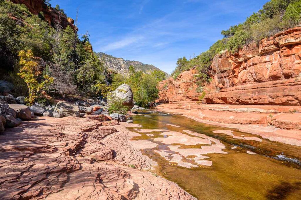
Distance: 120 miles/2 hours 20 minutes
Type: Nature & Outdoors
Best Time to Go: Summer for creek swimming
Oak Creek Canyon is often called Arizona’s answer to a mountain escape. It runs between Sedona and Flagstaff, where you’ll want to pull off constantly.
Slide Rock State Park is a crowd favorite, where you can literally slide down a smooth sandstone chute in the creek. The West Fork Trail is a cooler, shaded hike that crosses the stream repeatedly under tall canyon walls. During fall, the leaves flip to yellows and reds, making this one of Arizona’s most colorful corridors. Even just driving the canyon road is worth the trip on its own.
17. Payson & Mogollon Rim

Distance: 124 miles/2 hours 30 minutes
Type: Nature & Outdoors
Best Time to Go: Summer for high-elevation escapes
The Mogollon Rim crosses central Arizona, creating a dramatic elevation shift and a much cooler forest zone above the desert. Payson is your access point.
Once you get to town, head toward the Rim Road for cliffside overlooks that feel more like the Pacific Northwest than anything near Phoenix. There are lakes up top, like Woods Canyon and Willow Springs, both good for kayaking and short hikes. Below, Tonto Creek and the Water Wheel area are popular swimming holes,
18. Saguaro National Park

Distance: 137 miles/2 hours 20 minutes
Type: Nature & Outdoors
Best Time to Go to Saguaro: Spring for blooming cactus
Saguaro National Park is the only national park split in two by a city. Its eastern and western sections bracket Tucson and showcase the densest concentration of saguaro cacti in the U.S.
Both sides of the park have scenic drives and dozens of hiking trails. The east side, Rincon Mountain District, feels more remote and climbs into higher elevations, while the west side, Tucson Mountain District, is known for sunset views and easier access.
The cacti bloom in late spring, with bright white flowers perched like crowns on the arms. There are also ranger-led programs and nighttime astronomy events when the park stays open late.
19. Flagstaff

Distance: 144 miles/2 hours 30 minutes
Type: Urban
Best Time to Go to Flagstaff: Summer for cooler weather and festivals
Flagstaff sits at 7,000 feet, surrounded by ponderosa pine forests and anchored by Northern Arizona University. It’s a four-season town with skiing in the winter and trail access the rest of the year.
Downtown has a mix of old-school bars and hipster cafes. The Arizona Snowbowl offers chairlift rides even in summer, and the views of the San Francisco Peaks expand for miles. You’re also close to major sites like Lowell Observatory, where Pluto was discovered, and Walnut Canyon is just a short drive away.
20. Walnut Canyon National Monument
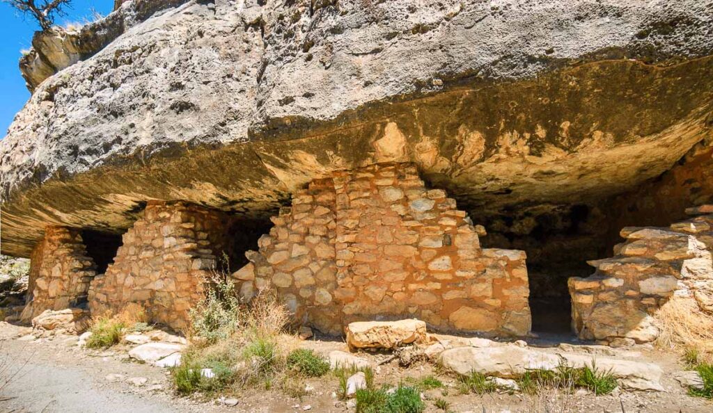
Distance: 151 miles/2 hours 20 minutes
Type: Historical & Cultural
Best Time to Go: Fall for hiking the loop trail
There are 25 ancient cliff dwellings you can walk right up to at Walnut Canyon. Built by the Sinagua over 700 years ago, these stone homes are tucked into limestone alcoves along a sharply cut canyon.
The Island Trail is the main draw. It’s a one-mile loop with stairs that take you down into the canyon and right past the preserved dwellings. It’s not a long hike, but it’s steep and very exposed, so early morning is best in warmer months. Interpretive signs along the way give context about how people lived here, farming on the rim and descending to fetch water.

Catherine, a seasoned travel writer, has lived in 4 different states and explored 36 states and 28 national parks. After spending two years embracing van life, she's now dedicated to sharing her vast knowledge of day trips across America. Catherine's other works has been referenced in major publications like MSN, Self, and TripSavvy.
| MY FAVORITE TRAVEL RESOURCES |
✈️ Find amazing guided tours and experiences with Viator to maximize your time! 🏘️ Plan ahead and secure your accommodation with Booking.com in advance. 🧾 Rent a car with Discovercars in advance and get the best prices for your day trip adventures. |