12 Most Dangerous Hikes in the US That Even Experienced Hikers Should Think Twice About

Some hikes are about the scenery; others are about pushing yourself to the very edge. I’ve trekked some of the toughest trails in the world, from Everest Base Camp and Kilimanjaro to knife-edge ridges in the Alps. While Angels Landing in Zion was intense, it wasn’t as scary as I expected.
But some of the routes on this list? They’re a whole different beast. From sheer cliffs and unpredictable weather to trails that disappear beneath your feet, these 12 most dangerous hikes in the US will leave even the most experienced hikers feeling maybe a little scared.

Half Dome Trail, Yosemite National Park, California
- Length: 16 miles round trip
- Elevation Gain: 4,800 feet
If pulling yourself up a sheer granite face using only cables sounds like fun, welcome to Half Dome, one of Yosemite’s most iconic hikes. The final 400 feet involve gripping steel cables bolted into the rock as you stare down at the valley floor thousands of feet below.
Many hikers start before dawn to avoid the midday heat and ensure enough time to safely descend. Permits are mandatory, and you’d have to win the lottery to get it.
About 60 people have to be rescued from Half Dome each year, usually because they underestimated how brutal this hike can get.

Mount Washington, New Hampshire
- Length: 8-10 miles round trip, depending on the trail
- Elevation Gain: 4,200 feet
Mount Washington has a reputation as the mountain that tries to kill you. The weather here is so unpredictable and violent that it once held the record for the fastest wind gusts ever recorded, 231 mph. Hikers face freezing temperatures, dense fog, and winds strong enough to knock you over, even in summer.
Despite its reputation, the views of the Presidential Range and the surrounding forests can stretch as far as Maine and Vermont.
Trails like the Tuckerman Ravine route feature steep ascents and rocky sections challenging even experienced hikers. Every year, search and rescue teams haul unprepared hikers off the mountain.
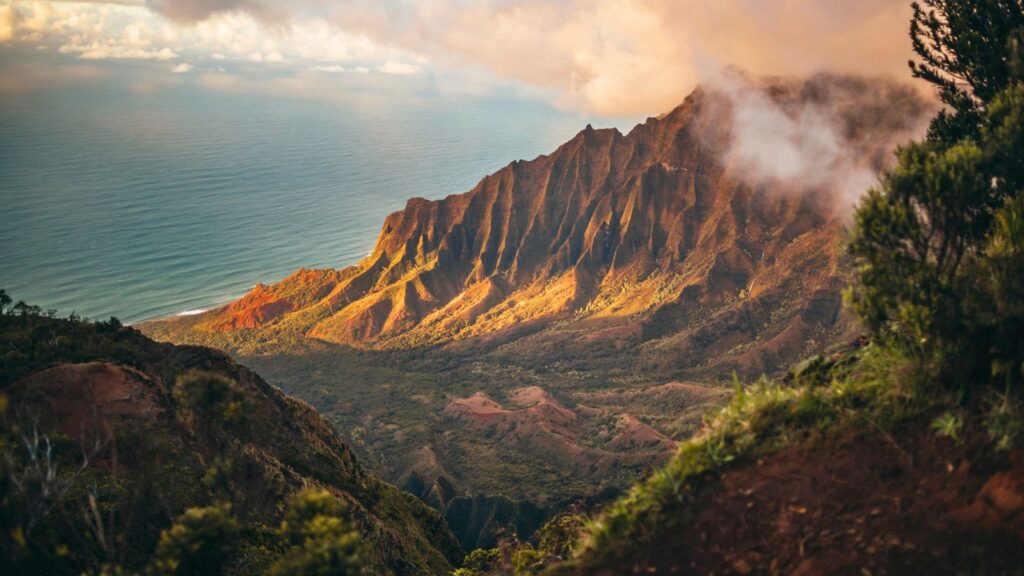
Kalalau Trail, Kauai, Hawaii
- Length: 22 miles round trip
- Elevation Gain: 6,512 feet
The Kalalau Trail along Kauai’s Na Pali Coast is one of the most scenic and dangerous hikes in the world. It starts at Ke’e Beach and snakes along the razor-sharp Na Pali Coast, clinging to cliffs that drop hundreds of feet into the Pacific. It’s beautiful, yes, but also deadly.
The section around Hanakapiai Beach is particularly treacherous. Flash floods can turn the trail into a raging torrent, and there are sections of narrow, slippery rock. It’s actually known as one of the most dangerous beaches in the country.
Permits are required beyond the first two miles. The final stretch to Kalalau Beach is the highlight, offering remote, untouched beauty that few experience.
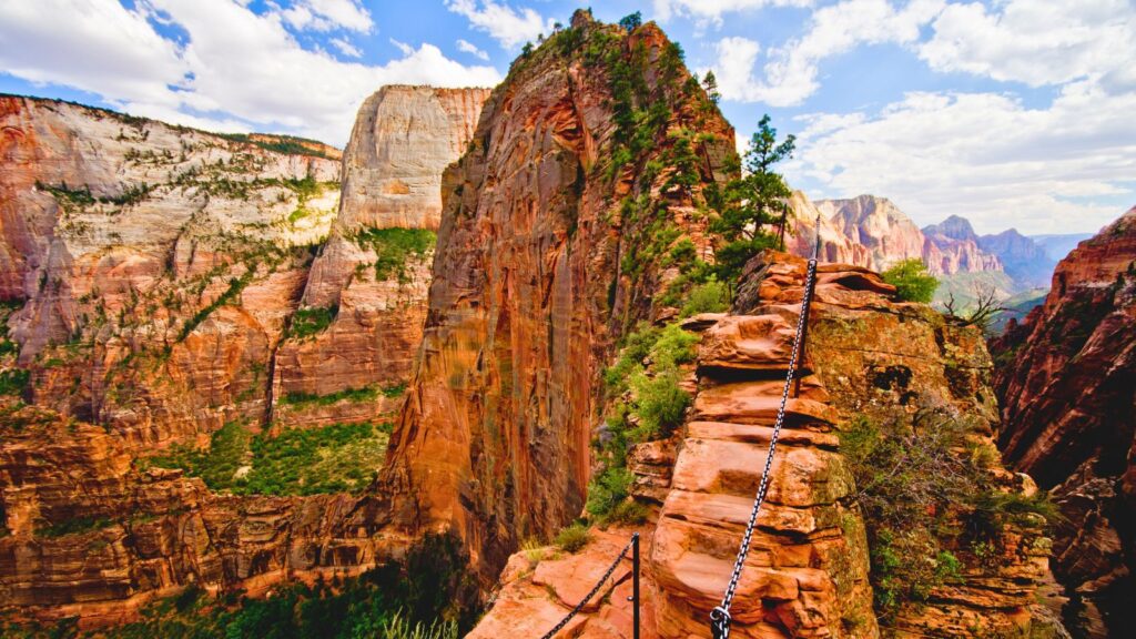
Angels’ Landing, Zion National Park, Utah
- Length: 4.3 miles round trip
- Elevation Gain: 1,827 feet
Angels’ Landing in Zion is a national park hike infamous for its terrifyingly narrow ridges as it is for its jaw-dropping views. The final stretch involves holding onto chains as you walk along a ridge barely wide enough for your boots. Although I never felt unsafe, looking over the edge would raise hairs on the back of anyone’s neck.
Approximately 17 people have died here since 2000. Despite that, it’s one of Zion’s most popular hikes. In recent years, the park has required a permit to limit the number of hikers.
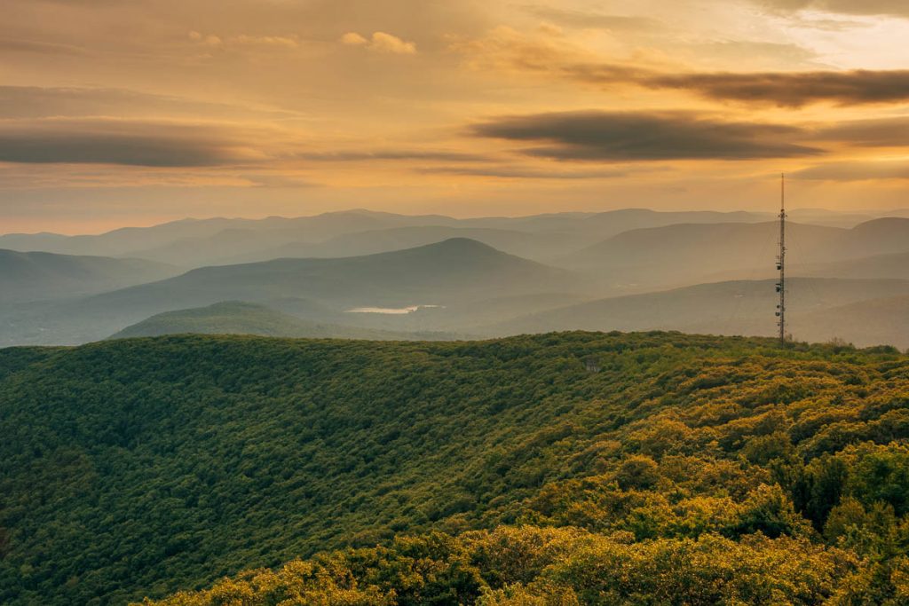
Devils’ Path, Catskills, New York
- Length: 24 miles round trip
- Elevation Gain: 8,389 feet
The Devil’s Path in the Catskills has a reputation for being one of the most challenging trails on the East Coast. It traverses six peaks, with relentless ascents and descents that have humbled plenty of experienced hikers.
Despite its grueling nature, the hike gives you incredible views of the New York Catskills’ forested valleys and rolling hills. Many hikers split the journey into two days, camping overnight to break up the challenge.
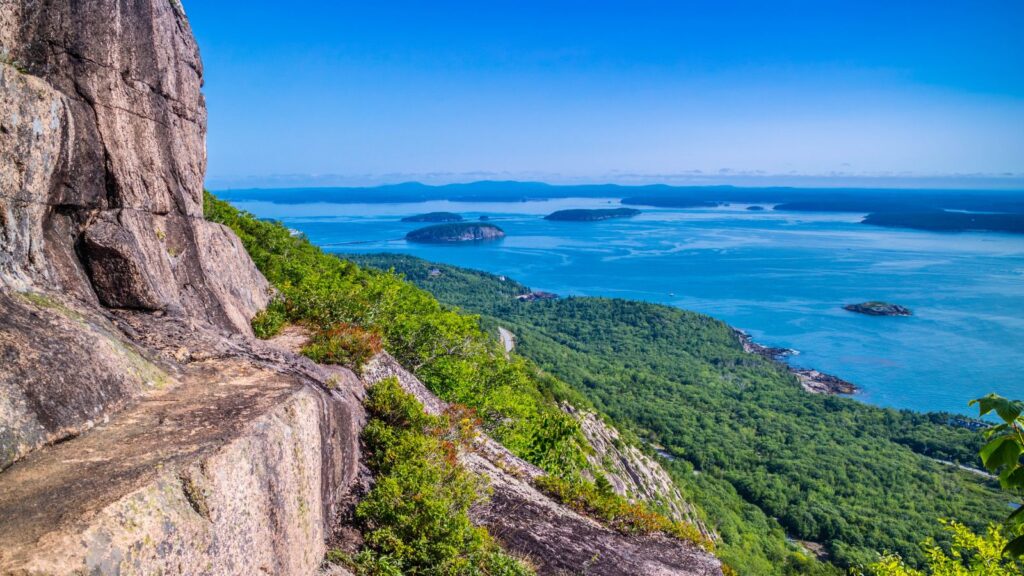
Precipice Trail, Acadia National Park, Maine
- Length: 2.6 miles loop
- Elevation Gain: 1,000 feet
Two miles doesn’t sound like much until you realize that half of it is spent clinging to iron rungs hammered into the side of a cliff. The Precipice Trail in Acadia is short but brutal, especially if you don’t love heights.
Rock scrambles, ladders, and exposed ledges make this hike feel more like an obstacle course than a trail. The steep climb leads to the summit of Champlain Mountain for views of Frenchman Bay and the rugged Maine coastline.
It’s closed in spring and early summer during the peregrine falcon nesting season, which should tell you how high and precarious this route actually is.
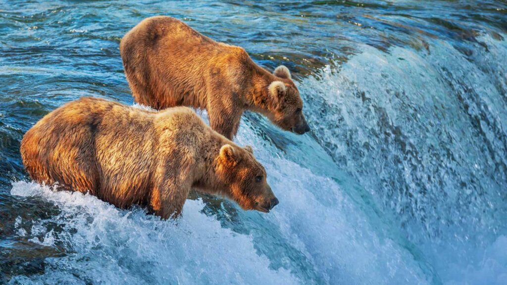
Rover’s Run, Anchorage, Alaska
- Length: 6.8 miles round trip
- Elevation Gain: 787 feet
Welcome to bear country. Rover’s Run looks like an easy, flat trail until you remember that Anchorage has some of the highest densities of scary wildlife like grizzly and black bears in North America.
The trail winds through thick forests and a salmon-rich creek, making it a favorite for bears, especially during salmon spawning season. Hikers are advised to carry bear spray, make noise, and maybe reconsider why they’re here in the first place.

Bright Angel Trail, Grand Canyon, Arizona
- Length: 15.8 miles round trip (to Plateau Point)
- Elevation Gain: 3,200 feet
Bright Angel Trail descends deep into the Grand Canyon, down its colorful layers to the winding Colorado River. Hiking down is easy, but the real pain comes on the way back up when the sun is blasting, and the temperature hits 110 degrees.
Every year, people get helicoptered out due to heat exhaustion, dehydration, or sheer exhaustion. There are water stops along the way, but don’t expect them to make the relentless ascent any less brutal.

Skyline/Muir Snowfield Trail at Mount Rainier, Washington
- Length: 9 miles round trip
- Elevation Gain: 4,744 feet
The Skyline Trail starts like a pleasant mountain stroll, but things get extreme once you hit the Muir Snowfield. You’re on a steep, slippery slope that’s basically one big crevasse-filled ice sheet.
The Muir Snowfield is a relentless climb, often requiring microspikes or crampons, even in summer. Mount Rainier’s weather changes rapidly, and clouds can obscure visibility in minutes.
At the top, see Mount Rainier’s glaciers and the surrounding Cascades. For those continuing to Camp Muir, this is the starting point for summit attempts.
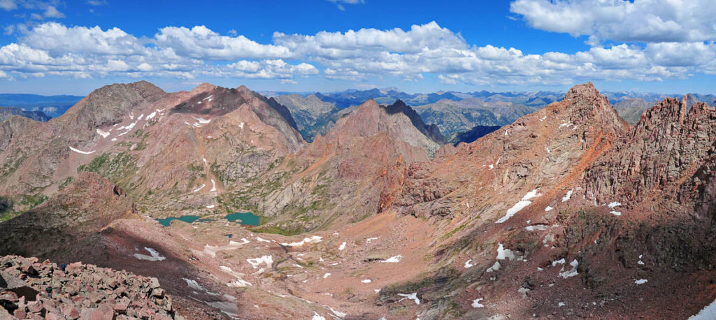
Capitol Peak via Knife’s Edge, Colorado
- Length: 15.9 miles round trip
- Elevation Gain: 5,300 feet
Capitol Peak is infamous for its Knife’s Edge, a narrow ridge with sheer drops on both sides that’s claimed more than a few lives. This climb is not recommended for those without significant alpine experience.
Before reaching the Knife’s Edge, hikers must navigate miles of steep switchbacks and boulder fields. The views, however, are astounding, with Capitol Lake and the Elk Mountains in the backdrops.
Capitol Peak is considered one of Colorado’s most difficult and dangerous fourteeners. The route demands serious climbing skills and nerves of steel. Every year, experienced mountaineers attempt it, and some don’t return.
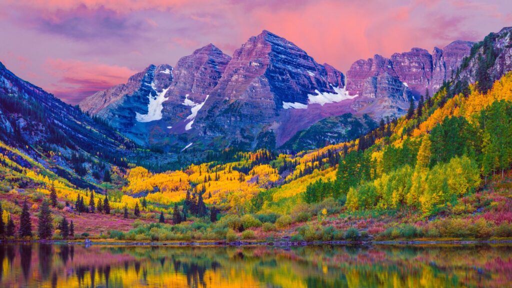
Maroon Bells Four Pass Loop, Colorado
- Length: 26.5 miles round trip
- Elevation Gain: 8,500 feet
Maroon Bells is one of the country’s most photographed spots, but the trail up to Crater Lake is far more challenging than the postcard suggests. The Four Pass Loop around the Maroon Bells is a legendary backcountry hike notorious for unstable rock, sudden weather changes, and the occasional moose encounter.
This demanding trek takes you over four mountain passes, each soaring above 12,000 feet, past alpine lakes, wildflower meadows, and jagged peaks.
Many hikers tackle it over three to four days, camping along the way to break up the intense climbs. Weather is notoriously unpredictable, and permits are required.

Huckleberry Mountain, Montana
- Length: 11.6 miles round trip
- Elevation Gain: 2,725 feet
Huckleberry Mountain in Glacier National Park is one of the less-trafficked trails in the park. It leads hikers through dense forests, open meadows, and ridgelines with expansive views.
The mountain trail is smack in the middle of Glacier National Park, and during the summer, grizzlies are out in full force. The trail is steep and long and frequently closed for bear activity.
If you go, bring bear spray and make a lot of noise.

Catherine, a seasoned travel writer, has lived in 4 different states and explored 36 states and 28 national parks. After spending two years embracing van life, she's now dedicated to sharing her vast knowledge of day trips across America. Catherine's other works has been referenced in major publications like MSN, Self, and TripSavvy.
| MY FAVORITE TRAVEL RESOURCES |
✈️ Find amazing guided tours and experiences with Viator to maximize your time! 🏘️ Plan ahead and secure your accommodation with Booking.com in advance. 🧾 Rent a car with Discovercars in advance and get the best prices for your day trip adventures. |