These 23 Dreamy Escapes Are Just a Short Drive from One of California’s Most Underrated Cities

You finally have a day to get away from Sacramento, but you don’t want to spend half of it stuck in traffic.
From lakefront towns to Gold Rush hideouts and coastal escapes, Northern California packs in way more variety than most people expect. Every spot on this list is within about three hours (or less), and they’re ranked by distance, so you can plan based on how much road you’re up for.
Back when I was balancing remote work and life on the road, I spent a lot of time in California driving up and down the state. And after a few too many overly ambitious detours, I figured out which places were actually worth the miles. These are the day trips from Sacramento that are actually worth it and easy to fit into a busy week.
Easy Day Trips from Sacramento: Less than 1 Hour
1. American River Parkway

Distance: 2.3 miles / 10 minutes
Type: Nature & Outdoors
Best Time to Go: Year-round
Spanning over 30 miles along the American River, this greenbelt cuts straight through Sacramento. It’s one of the largest urban parks in the country, and you can access it minutes after leaving downtown.
The Jedediah Smith Memorial Trail runs the length of the parkway and is a favorite for locals. Rafting the river on a hot day is practically a rite of passage here, especially the stretch between Sunrise and Ancil Hoffman.
2. Folsom

Distance: 22 miles / 37 minutes
Type: Historical & Cultural
Best Time to Go to Folsom: Fall for lake views and mild temps
Folsom’s prison may have put it on the map, but the city blended it with Gold Rush relics, accessible trails, a big lake, and enough museums to keep things interesting.
Start at the Folsom Prison Museum if you’re curious about Johnny Cash’s visit or just want to see a handmade shank from 1915. Walk through the Historic District along brick sidewalks and storefronts with 19th-century roots. Nearby Lake Natoma is perfect for a paddleboard session or walking the Johnny Cash Trail, a public art-filled route that loops around town and connects back to the American River Parkway.
3. Yolo County Flower Fields

Distance: 17.1 miles / 25 minutes
Type: Nature & Outdoors
Best Time to Go: Spring for peak blooms
In late spring, farmland west of Sacramento bursts into color with row after row of sunflowers, lavender, and seasonal wildflowers. This only happens for a few weeks every year.
The bloom timing shifts slightly each year, but mid-June to mid-July is usually safe for sunflower season. Pull over along County Roads 87 and 29 for the best views, but be respectful of private property and posted signs.
4. Davis

Distance: 14.8 miles / 20 minutes
Type: Educational
Best Time to Go to Davis: Spring for green campus and markets
UC Davis has helped turn this college town into a hub of cycling paths and research labs. Check out the UC Davis Arboretum, a 100-acre public garden with walking trails along Putah Creek. Downtown Davis is full of bookstores, record shops, and little galleries worth poking into. If you’re here on a Saturday, the Davis Farmers Market in Central Park has earned its reputation as one of the best in the region.
5. Lodi

Distance: 35 miles / 45 minutes
Type: Artistic
Best Time to Go to Lodi: Fall for harvest season
Lodi grows more wine grapes than Napa and Sonoma combined but without the polished tasting rooms and price tags. Many of the vineyards are family-owned and operated, with open patios and low-pressure tastings.
The Lodi Wine Visitor Center is a solid place to start if you’re new to the area. Murals and small galleries give downtown Lodi a sense of creative energy, and there’s a growing number of artists using old warehouses as studios.
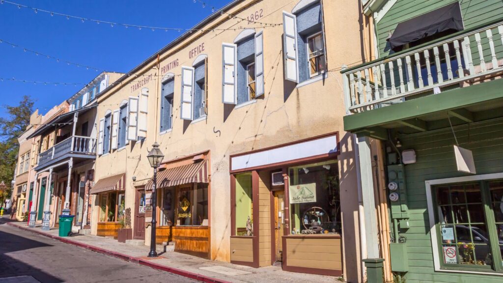
6. Amador County

Distance: 54.9 miles / 1 hour 25 minutes
Type: Historical & Cultural
Best Time to Go: Fall for gold country colors
Gold was discovered in Amador County in the 1850s, and the towns that popped up still carry that edge of early California ambition. There’s a frontier feel that hasn’t been scrubbed clean by modern tourism.
Start in Sutter Creek, a town with wood-plank sidewalks and actual saloons that haven’t been turned into theme bars. Main Street is lined with antique shops and small museums. Jackson, Amador City, and Plymouth are all worth quick stops, especially if you’re into history or old mining sites. Wineries also dot the hills between towns.
Best Day Trips from Sacramento: Less than 2 Hours
7. Nevada City
Distance: 64.0 miles / 1 hour 35 minutes
Type: Historical & Cultural
Best Time to Go: Fall for foliage and festivals
At one point, Nevada City had more millionaires per capita than anywhere else in the country. That Gold Rush wealth left behind architecture and an old-town feel that is still standing today.
The downtown is compact, full of 19th-century buildings that now house independent shops, galleries, and bars. The Nevada Theatre is California’s oldest running theater and still puts on live performances. South Yuba River State Park is nearby and makes a great detour, especially when it’s warm enough to swim.
8. Coloma

Distance: 46.4 miles / 1 hour 15 minutes
Type: Educational
Best Time to Go: Spring for river rafting season
Gold was officially discovered here in 1848, setting off California’s population boom. The town now functions as a living museum and one of the state’s best-known outdoor classrooms.
Marshall Gold Discovery State Historic Park anchors the area with preserved cabins, blacksmith shops, and interpretive trails. You can see the actual site where James Marshall found gold in the American River. Coloma is also a major launch point for whitewater rafting trips on the South Fork, with outfitters lining the riverbank once spring hits.
9. Placerville

Distance: 43.6 miles / 1 hour
Type: Urban
Best Time to Go to Placerville: Winter for apple stands and snow-dusted hills
Known as “Old Hangtown,” Placerville was once the roughest stop on the way to the Sierra. These days, Main Street feels like a Western movie set but with actual functioning businesses. Pop into galleries, bookstores, and antique shops between the bell tower and the Cary House Hotel. El Dorado County’s wine scene is growing fast, with some of the tasting rooms set up right in town.
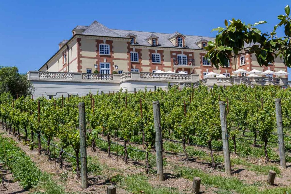
10. Napa Valley
Distance: 64.8 miles / 1 hour 15 minutes
Type: Artistic
Best Time to Go to Napa Valley: Fall for harvest and crush
Napa Valley produces roughly 4 percent of California’s wine but accounts for over 30 percent of its wine tourism. That stat says a lot about the draw of this place.
Winery visits are the main event here, and while the valley has a luxury image, it’s still possible to do a Napa day trip from San Fran or Sacramaneto without spending hundreds. Drive up Highway 29 or the Silverado Trail and pick one or two stops rather than trying to cram in too much. Yountville has art installations and curated shops that go beyond wine.
11. Sonoma
Distance: 71 miles / 1 hour 30 minutes
Type: Historical & Cultural
Best Time to Go to Sonoma: Spring for green vineyards and fewer crowds
Sonoma is where the California wine story actually started. The state’s first vineyards were planted here in the early 1800s, and it’s a more low-key, cheaper alternative to its neighbor Napa Valley.
Sonoma Plaza is the center, lined with historic buildings and a walkable layout, especially compared to Napa. The Mission San Francisco Solano sits at one end and marks the northernmost outpost of the original Spanish missions. You can taste wine here without ever getting in a car.
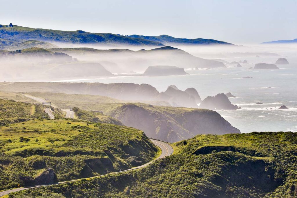
12. Bodega Bay
Distance: 109 miles / 2 hours
Type: Nature & Outdoors
Best Time to Go to Bodega Bay: Summer for coastal breeze and hikes
Alfred Hitchcock filmed The Birds here, but Bodega Bay isn’t eerie in real life. It’s quiet, foggy, and full of open coastline that stretches on for miles.
Bodega Head is the go-to for coastal walks with steep cliffs and ocean views. If the weather cooperates, you might spot whales from the overlook. Doran Regional Park has calmer water and easier beach access, especially good for tidepooling or a picnic. Inland, there are a few small seafood shacks and shops.
13. Point Reyes National Seashore
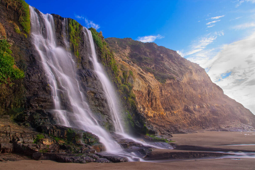
Distance: 98.2 miles / 1 hour 55 minutes
Type: Wildlife
Best Time to Go: Winter for elk and waves
Point Reyes is the only national seashore on the West Coast with a working dairy farm inside its borders. It’s also home to one of the windiest lighthouses in the country.
Hike the Tomales Point Trail to see tule elk in the distance, or head to Drakes Beach for dramatic cliffs. The Point Reyes Lighthouse is worth the steep staircase for the view alone. The park’s terrain shifts from open coastal prairie to mossy forest within minutes, so each trail feels like its own zone.
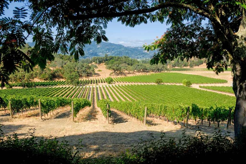
14. Russian River Valley

Distance: 112 miles / 2 hours
Type: Nature & Outdoors
Best Time to Go: Summer for swimming and tubing
The Russian River is where wine country and lazy summer river days intersect. Healdsburg is the unofficial jumping-off point, with river access nearby and tasting rooms within walking distance. Johnson’s Beach in Guerneville is a classic float spot.
Several spots along the river rent canoes, kayaks, and tubes for easy drifting. Once you find your spot, you really just spend all day mingling with other groups on your little floatie.
15. San Francisco
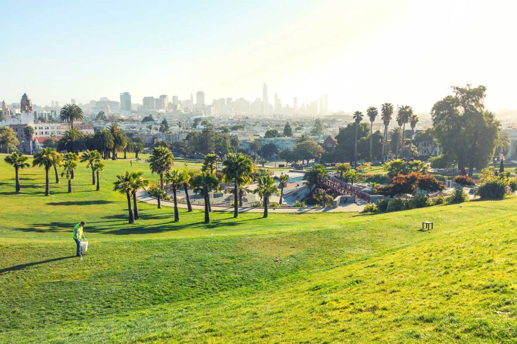
Distance: 87.5 miles / 1 hour 50 minutes
Type: Urban
Best Time to Go to San Francisco: Fall for sun and fewer crowds
Most people think California is just sun all the time, but SF really puts a dent in that belief. On warm days when the fog Karl is at Bay, everyone heads to Dolores Park to enjoy the sun.
Stick to one San Francisco neighborhood or two and ditch the car when you can as parking is impossible, especially on the hills of Chinatown. The Ferry Building is a solid starting point, with direct access to the Embarcadero and views across the bay. Explore the Mission for food and parties and head into Golden Gate Park to go all the way to the original hippieville, Haight-Ashbury.
16. Lake Tahoe
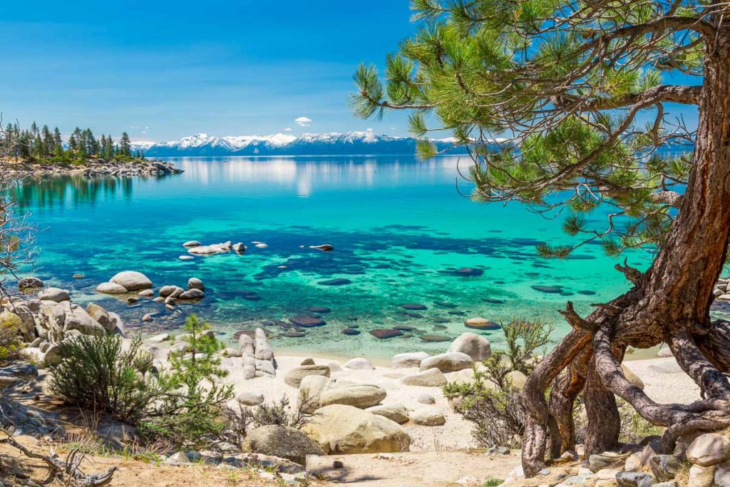
Distance: 113 miles / 2 hours
Type: Nature & Outdoors
Best Time to Go to Lake Tahoe: Summer for beach hikes and clear water
Lake Tahoe is the second deepest lake in the United States and one of the clearest. It also happens to be two hours from Sacramento on a good day.
Choose your side depending on what you want. South Lake is built-up with casinos, marinas, and more options for gear rental and endless boat ride bookings.
North Lake has smaller towns like Kings Beach and Tahoe City, with easier access to trailheads and public beaches. Sand Harbor and Emerald Bay are two of the most photographed spots, and both are incredible.
Sacramento Day Trips: Around or Less than 3 Hours
17. Monterey Bay Coast
Distance: 186 miles / 2 hours 45 minutes
Type: Nature & Outdoors
Best Time to Go to Monterey: Fall for calmer ocean and clear skies
Monterey Bay is home to one of the largest underwater canyons on the planet, deeper than the Grand Canyon in some places.
The Monterey Bay Aquarium is the headline attraction, especially for its open sea tank and jellyfish exhibits. After that, stroll Cannery Row or walk the Coastal Recreation Trail that connects Pacific Grove to Seaside. Drive south on Highway 1 toward Carmel, and you’ll hit 17-Mile Drive, one of California’s most scenic routes.
18. Reno, Nevada

Distance: 130 miles / 2 hours 15 minutes
Type: Urban
Best Time to Go to Reno: Winter for snow sports and events
A lot smaller than Vegas, Reno bills itself as “The Biggest Little City in the World” and leans into the balance between casinos and outdoor access.
Midtown Reno is packed with street art and vintage shops. The Riverwalk District gives you a walkable zone of interesting places to stop in along the Truckee River. Lake Tahoe is right there. The city also works as a gateway for winter sports with easy drives to Mt. Rose or Northstar.
19. Lassen Volcanic National Park
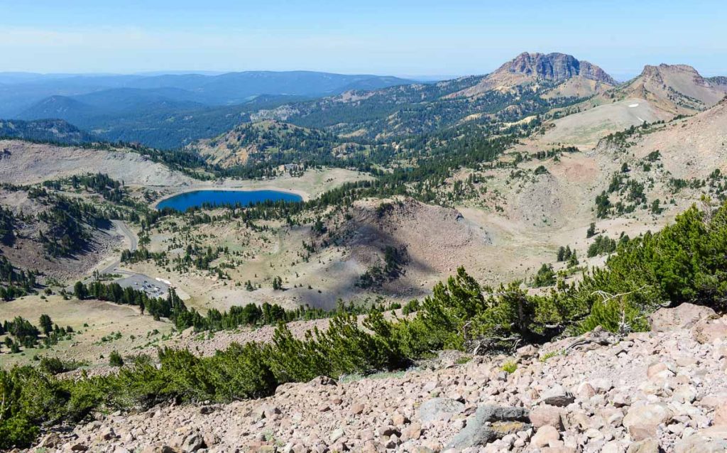
Distance: 180 miles / 3 hours
Type: Nature & Outdoors
Best Time to Go to Lassen Volcanic: Summer for open roads and trail access
Every kind of volcano exists here. Lassen is the only national park in the world where you’ll find all four major types in one place. It’s like a much smaller version of Yellowstone and given it’s remote location, very little visited compared to other California parks.
Bumpass Hell Trail leads you to boiling mud pots and steaming vents that feel like another planet. The road through the park is seasonal and usually opens in late spring, so plan accordingly.
20. Mount Shasta
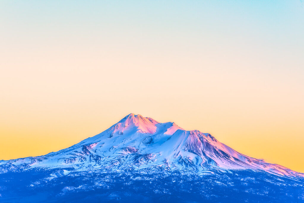
Distance: 210 miles / 3 hours 10 minutes
Type: Nature & Outdoors
Best Time to Go to Mount Shasta: Summer for clear hikes and climbing access
Mount Shasta rises over 14,000 feet and is visible from more than 100 miles away on a clear day. It’s the second-highest peak in the Cascades and a magnet for climbers, hippies, and van lifers.
Shasta City is the closest town and acts as your launch point for hiking trails like Panther Meadow, Bunny Flat, and Castle Lake. For less elevation, drive around to McCloud Falls and explore the three-tiered waterfall hike. People come here for everything from mountaineering to yoga retreats. Some of the best hot springs I’ve ever been are not too far away too.
21. Mount Tamalpais

Distance: 101 miles / 2 hours
Type: Nature & Outdoors
Best Time to Go: Spring for wildflowers and ocean views
Mount Tam sits just north of San Francisco and has been a favorite escape for Bay Area locals since the 1800s. It’s where the mountain bike was invented, and the trail system is still one of the best around.
Dipsea Trail, Steep Ravine, and Matt Davis are some of the most-loved hikes, weaving through redwoods and climbing toward ocean overlooks. On a clear day, the East Peak offers views that reach as far as the Sierra. You can also park near Pantoll Station and connect to shorter loops through the forest.
22. Yosemite National Park

Distance: 140 miles / 3 hours
Type: Nature & Outdoors
Best Time to Go to Yosemite: Spring for waterfalls and green trails
Yosemite is one of the most visited parks in the national park system, getting more than four million visitors a year. The cliffs, domes, and rivers inside this park make it one of the most photographed places in the country.
If you’re here for the day, focus on Yosemite Valley. Glacier Point, Tunnel View, and the Yosemite Falls trail are high-impact, low-effort ways to see the big landmarks. Spring is ideal if you want full waterfalls without summer crowds. If time allows, drive up to Tuolumne Meadows or walk the Mist Trail to Vernal Fall. Even a few hours here feels like time well spent.
23. Pinnacles National Park

Distance: 180 miles / 3 hours
Type: Nature & Outdoors
Best Time to Go to Pinnacles: Spring for wildflowers and condors
Pinnacles is the newest national park in California, though the rock spires and caves here have been forming for millions of years. It’s one of the best places in the country to spot endangered California condors in flight.
Pinnacles is split between East and West entrances, and there’s no road connecting the two. From the East, you can hike through Bear Gulch Cave or take the High Peaks Trail for steep climbs. The West side has quicker access to the rocky formations but fewer facilities.

Catherine, a seasoned travel writer, has lived in 4 different states and explored 36 states and 28 national parks. After spending two years embracing van life, she's now dedicated to sharing her vast knowledge of day trips across America. Catherine's other works has been referenced in major publications like MSN, Self, and TripSavvy.
| MY FAVORITE TRAVEL RESOURCES |
✈️ Find amazing guided tours and experiences with Viator to maximize your time! 🏘️ Plan ahead and secure your accommodation with Booking.com in advance. 🧾 Rent a car with Discovercars in advance and get the best prices for your day trip adventures. |